
Integrating artificial intelligence into geodesy and topographic surveying
From drone measurements to informed terrain analysis
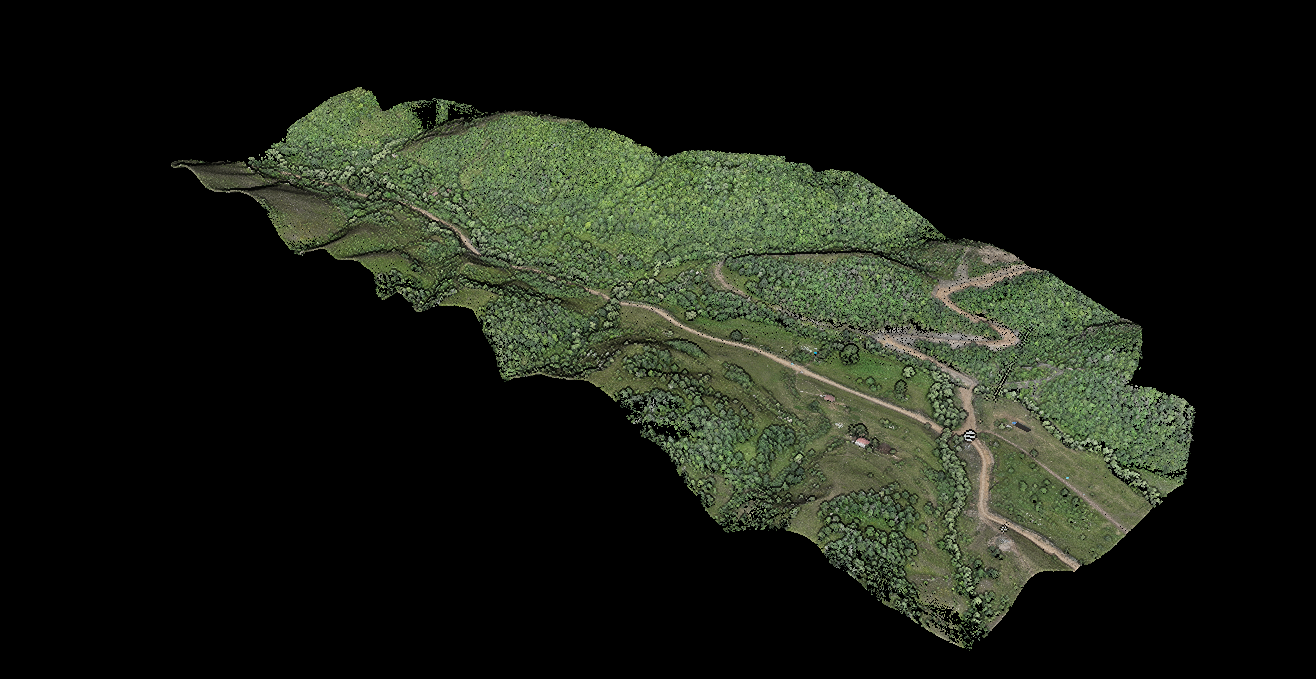
A coloured 3D point-cloud example from GeoTotal’s LiDAR service page. 1
Measurement remains the foundation
Surveying establishes terrain conditions, coordinates and elevations to provide reliable design data. Drones, GNSS instruments and laser scanners accelerate acquisition. Artificial intelligence can help classify large datasets, identify objects and detect change, but it does not remove the need for reliable measurement.
Integration works in two directions
AI can be introduced into processing, for example to help separate ground, vegetation and buildings in a point cloud. In the other direction, accurate surveying data provide training and validation material for AI models. Incorrect coordinate systems or insufficiently checked inputs cannot produce dependable engineering results merely through faster analysis. Measurement, processing and professional review must work together.
What AI can do with LiDAR data
LiDAR returns form a point cloud representing terrain, trees, structures and other objects. Correct classification matters as much as point count. USGS research investigates deep-learning approaches to classifying LiDAR points. 2 Models trained on appropriate data can accelerate classification. However, automated classification is not necessarily AI: geometric, rule-based algorithms are also used. The supplied illustrations explain processing; they do not establish that a particular AI model was used. 3 Colour by elevation is not an object-class or AI-result map. In the ground-classification image, brown denotes Ground Point and grey denotes Point Not Classified; grey points cannot all be called trees.
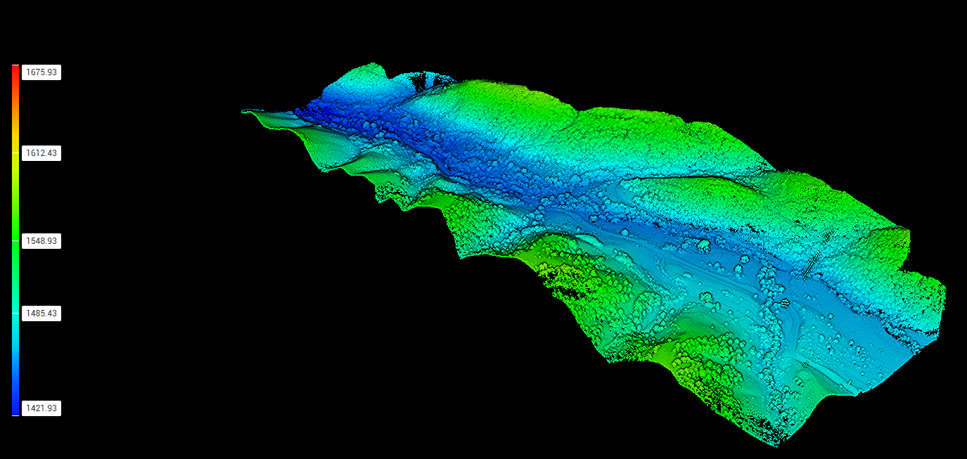
Point cloud coloured by elevation. Colours indicate height differences, not automatically object classes or AI output. 1
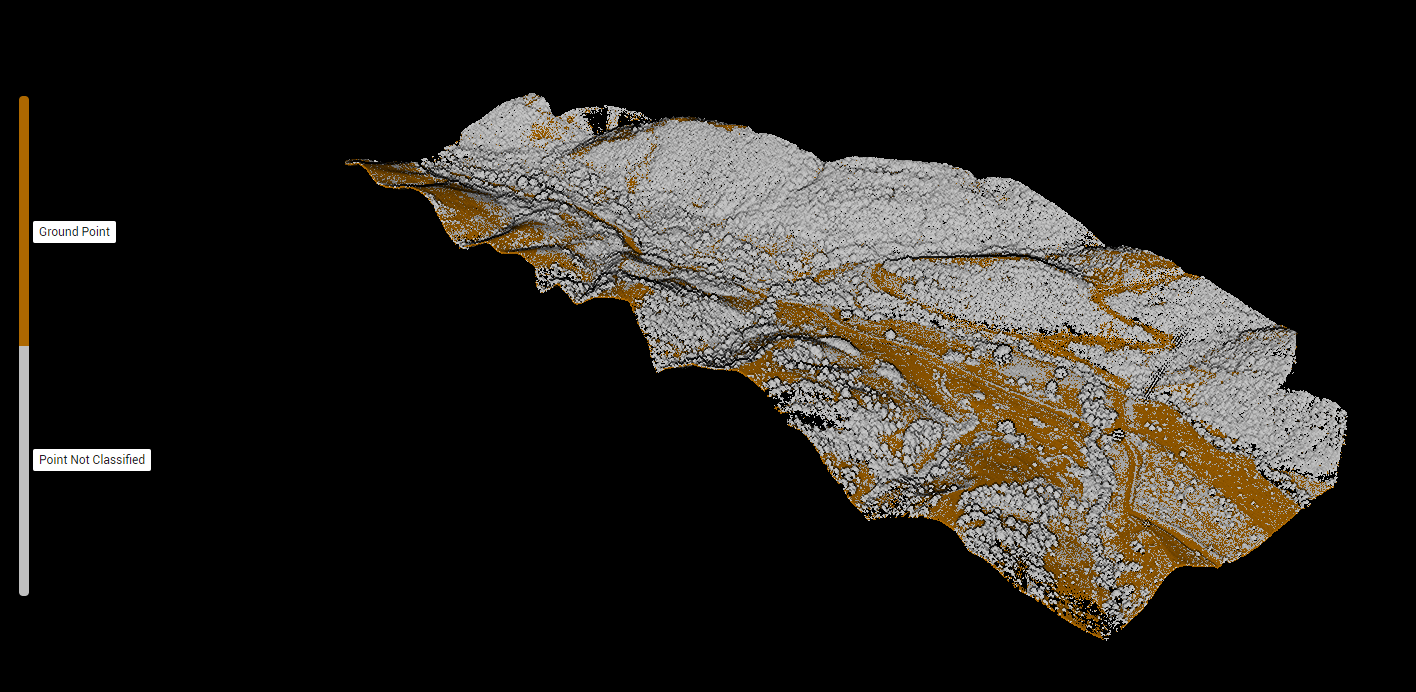
Ground points separated from other points. Brown: Ground Point; grey: Point Not Classified. Grey is not a tree class. 1
Hadrut: from drone survey to restoration planning
For the restoration and redevelopment of Hadrut, GeoTotal’s work associated with SP Architects included topographic surveying of existing buildings and drone LiDAR measurements. DJI Matrice 350 RTK and Zenmuse L2 collected terrain and existing-condition data. 4 Processing in DJI Terra included classification and the preparation of a digital terrain model (DTM), digital surface model (DSM) and detailed 3D model. Digital topographic plans supported restoration and design. A suitable AI model could help select buildings, roads and vegetation for initial review, or highlight changes where repeat surveys exist. These are possible future processing applications, not evidence that AI was used on the project. An AI-selected outline must be checked against survey data before inclusion in an engineering plan; recognising a building does not establish its coordinates to the required accuracy.
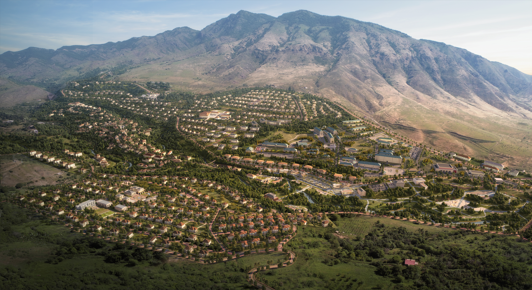
Project visualisation shown on GeoTotal’s Hadrut page; not a photograph of an AI measurement result. 4
Tugh: terrain, trees and site analysis
For the restoration of Tugh and surrounding project villages, GeoTotal used DJI Matrice 350 RTK and Zenmuse L2 for LiDAR and topographic surveys. Work included terrain measurement, DJI Terra processing, a 3D model and the determination of tree coordinates and counts. 5 With suitable LiDAR and imagery, a model could support initial tree-crown selection, vegetation grouping and comparisons between areas. Touching crowns, dense vegetation and uneven point density affect results; automated counts may need field checks and expert correction. Classified data link planting to terrain and construction areas and can support tree protection and landscaping. A DTM represents the ground, whereas a DSM includes the upper surfaces of structures and vegetation. Misclassifying tree tops as ground distorts terrain models and volume calculations.
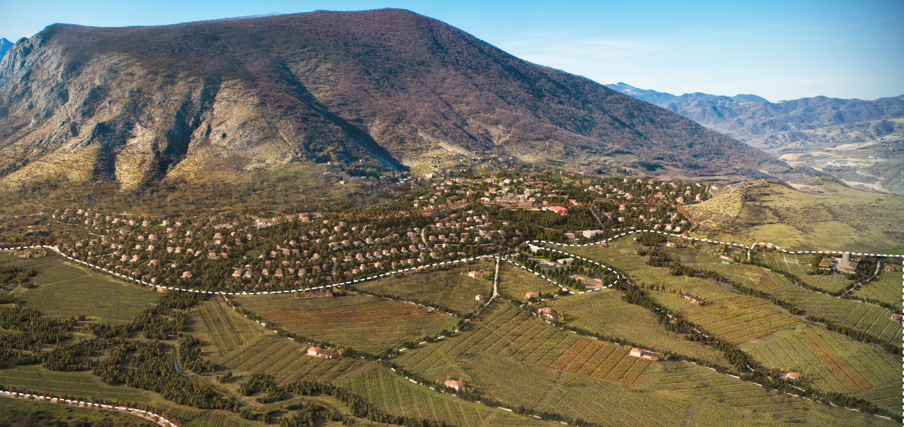
Project visualisation shown on GeoTotal’s Tugh page. 5
How surveying data support AI training
Training requires reliable examples of ground points, building outlines and trees. Correctly georeferenced orthophotos, checked point clouds and expert-approved labels are essential. Esri documentation identifies the quality and diversity of training data as important conditions. 6 A model trained only on open, flat terrain may perform differently in dense settlements or wooded slopes. Validation should use areas excluded from training. Nearly identical parts of one area in both training and validation can make results look better than they are. Data should include acquisition dates, coordinate and height systems, instruments, flight settings, check points and processing methods, enabling later interpretation and comparisons.
Regional analysis is not construction measurement
Prithvi geospatial models, developed through collaboration between NASA, IBM Research and Jülich Supercomputing Centre, support analysis of satellite data for floods, burn scars and land cover. 7 They demonstrate the relationship between spatial data and AI. Regional satellite classification is not a substitute for centimetre-level construction surveying.
Assessing practical value for the client
Compare processing time, manual correction effort, classification errors and final product quality for the same area. No single savings percentage applies to every project. Results depend on data quality, terrain complexity and software capabilities. AI may reduce repetitive tasks, flag doubtful areas and let engineers focus on checks. Data preparation, model adaptation and verification also take time.
Accuracy and engineering review
Classification accuracy and coordinate accuracy are different measures. An object may be recognised correctly while tied to the wrong reference system. Classification quality must therefore be assessed separately from horizontal and vertical errors. Independent check points should not be used in processing. Doubtful areas should be examined in cross-sections, orthophotos and, where needed, ground measurements. A model’s confidence score is not a surveying accuracy certificate. Areas not captured in images or LiDAR may need additional measurements. AI-inferred surfaces must be distinguished from measured surfaces; visually filling gaps with generative tools does not create engineering measurements.
Frequently asked questions
Does AI replace the surveyor? Planning, control selection, error checks and acceptance require professional judgment; AI assists specific processing stages. Is every automatic 3D model an AI result? No: photogrammetric calculation, geometric filtering and surface construction can use conventional algorithms. Does AI automatically remove GNSS error? No general claim is justified: data quality, reference stations, observation conditions and processing still matter, and independent checks remain necessary. May survey files be uploaded to an AI service? Project confidentiality, client requirements and the service’s data-retention rules should be reviewed first; processing may need to remain local.
From measurements to usable project data
GeoTotal provides geodetic and topographic surveying, drone LiDAR and photogrammetry. The site, area, required scale and deliverable formats guide the choice of measurement and processing methods. Share your technical brief for a topographic plan, point cloud or digital model. Related service and project pages are linked below.